[HOME]
NOTE THAT THIS PAGE WAS SUBSTANTIALLY REVAMPED ON 01/03/11
BYLONG SPECIFIC INFORMATION - Summary
For news items directly related to Bylong, refer to the News Reports page
1. MAPS
(Note that a .pdf document of all the maps in this section can be viewed and downloaded via this link.)
1.1. Overview Maps
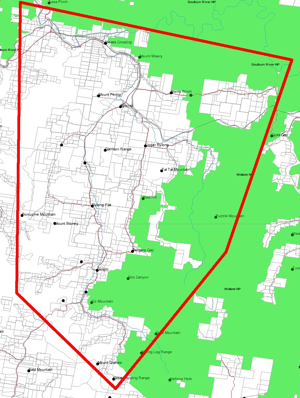
1.1.1. Greater Bylong Valley Area
We are defining the Greater Bylong Valley Area as shown in the map below (outlined in red).
The area runs from Coggan in the west to Murrumbo in the east and from the Goulburn River in the north to Growee in the south. (Click for larger image.)
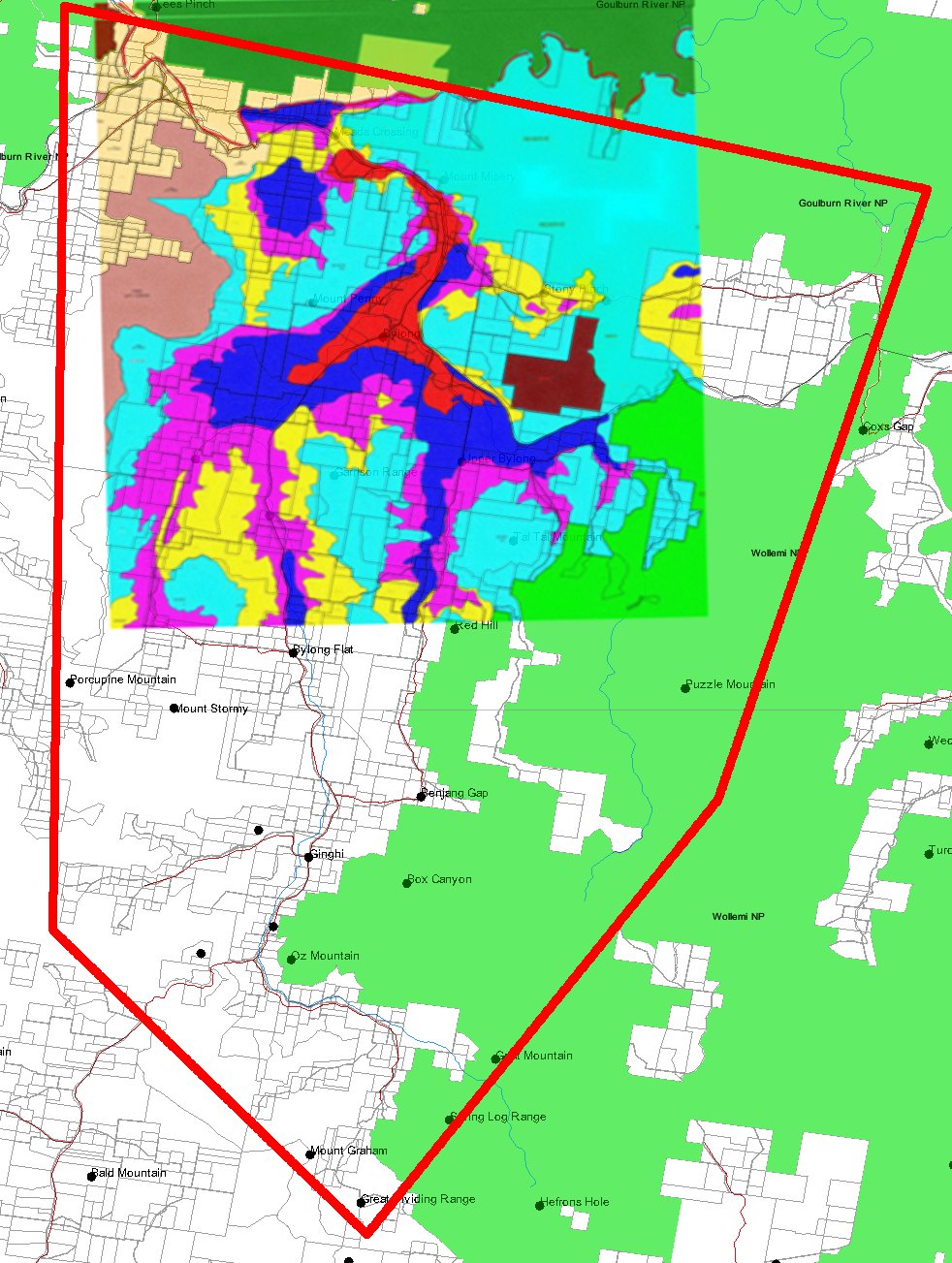
1.1.2. Satellite Imagery
Here is the same map, overlayed with satellite imagery from Google Earth
The area runs from Coggan in the west to Murrumbo in the east and from the Goulburn River in the north to Growee in the south. (Click for larger image.)
1.1.3 Agricultural Land Classes
Much of the area covered by the Mount Penny (Cascade/White Energy) and Bylong (Cockatoo/KEPCO) ELs is prime agricultural land. While definitions vary, 'prime' agricultural land is often taken as being Class 1 or Class 2 (although some insist on restricting this just to Class 1, while others prefer a definition that takes in Classes 1-4).
The map below shows land class information (provided by the Mid-Western Regional Council) overlaid on the Greater Bylong Valley area. (At the moment, the land class information only covers the northern part of the valley, in the area of the proposed Mt Penny and Bylong developments.) LEGEND: Red = Class 1, Dark Blue = Class 2, Pink = Class 3, Light Blue = Class 4. (Click for larger image.)
For a map that superimposes the rough outlines of the Mt Penny (EL 7406) and Bylong (AUTH 287, AUTH 342) areas on this land class information, click here.
1.2. Titles and Applications
1.2.1. Current Coal Titles
Current Exploration Leases and Authorities for coal are shown in the map below, each coloured differently. (The exception is AUTH 342 and AUTH 287 which are both coloured light blue, since they are both owned by Anglo Coal (which have both been sold to Cockatoo/KEPCO and are pending transfer) and are being treated as one combined area). Note that AUTH 286 is a very large authority, still owned by NSW Industry and Investment (I&I) and is split into a number of what are now disjoint areas. The same is true for EL 6676.) (Click for larger image.)
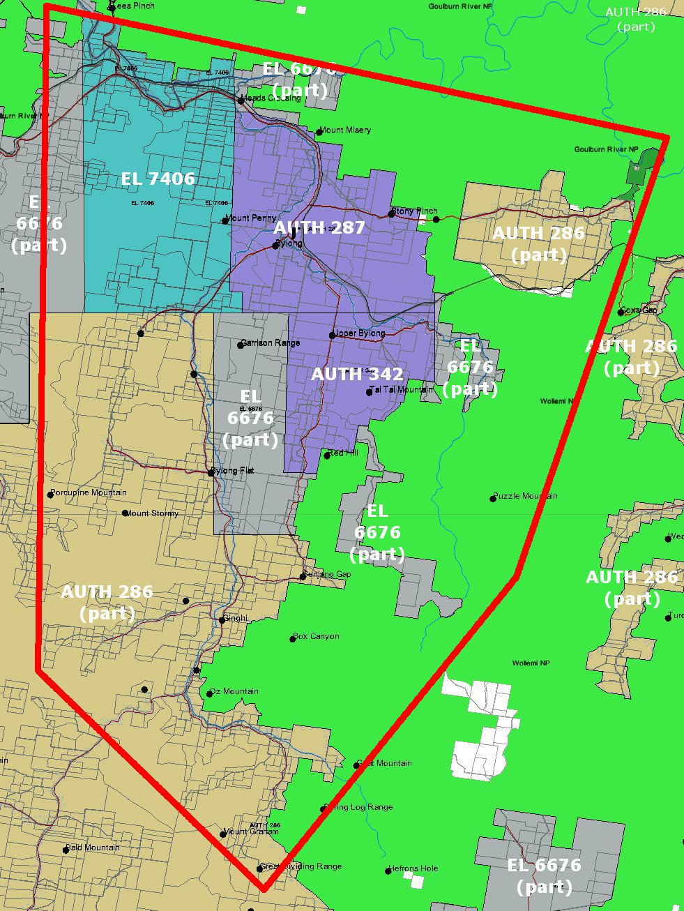
Details regarding each of the ELs and Authorities shown in the map are given below:
|
Title Code |
No. |
Act Year |
Company |
Grant Date* |
Expiry Date |
Renewal Date |
Type/Group |
|
CURRENT COAL TITLES |
|||||||
|
EL |
7406 |
1992 |
MT PENNY COAL PTY LTD |
21 Oct 2009 |
21 Oct 2014 |
21 Oct 2009 |
Coal |
|
AUTH |
342 |
1973 |
ANGLO COAL (BYLONG) PTY LTD |
09 Feb 1984 |
27 Jul 2011 |
31 Mar 2009 |
Coal |
|
AUTH |
287 |
1973 |
ANGLO COAL (BYLONG) PTY LTD |
12 Jan 1982 |
27 Jul 2011 |
31 Mar 2009 |
Coal |
|
AUTH |
286 |
1973 |
DIRECTOR GENERAL NSW DEPT OF INDUSTRY AND INVESTMENT ON BEHALF OF THE CROWN |
02 Nov 1981 |
02 Apr 2011 |
18 Dec 2009 |
Coal |
|
EL |
6676 |
1992 |
DIRECTOR GENERAL NSW DEPT OF INDUSTRY AND INVESTMENT ON BEHALF OF THE CROWN |
21 Nov 2006 |
20 Nov 2011 |
21 Oct 2009 |
Coal |
Note that EL 7406, currently owned by Mount Penny Coal (Cascade Coal) is in the process of being sold to White Energy while AUTH 287 and AUTH 342 are in the process of being sold to KEPCO of Korea (to be operated by Cockatoo Coal).
1.2.2. Mineral Titles Applications
Mineral titles applications currently in progress are shown in the map below, each coloured differently. (Click for larger image.)
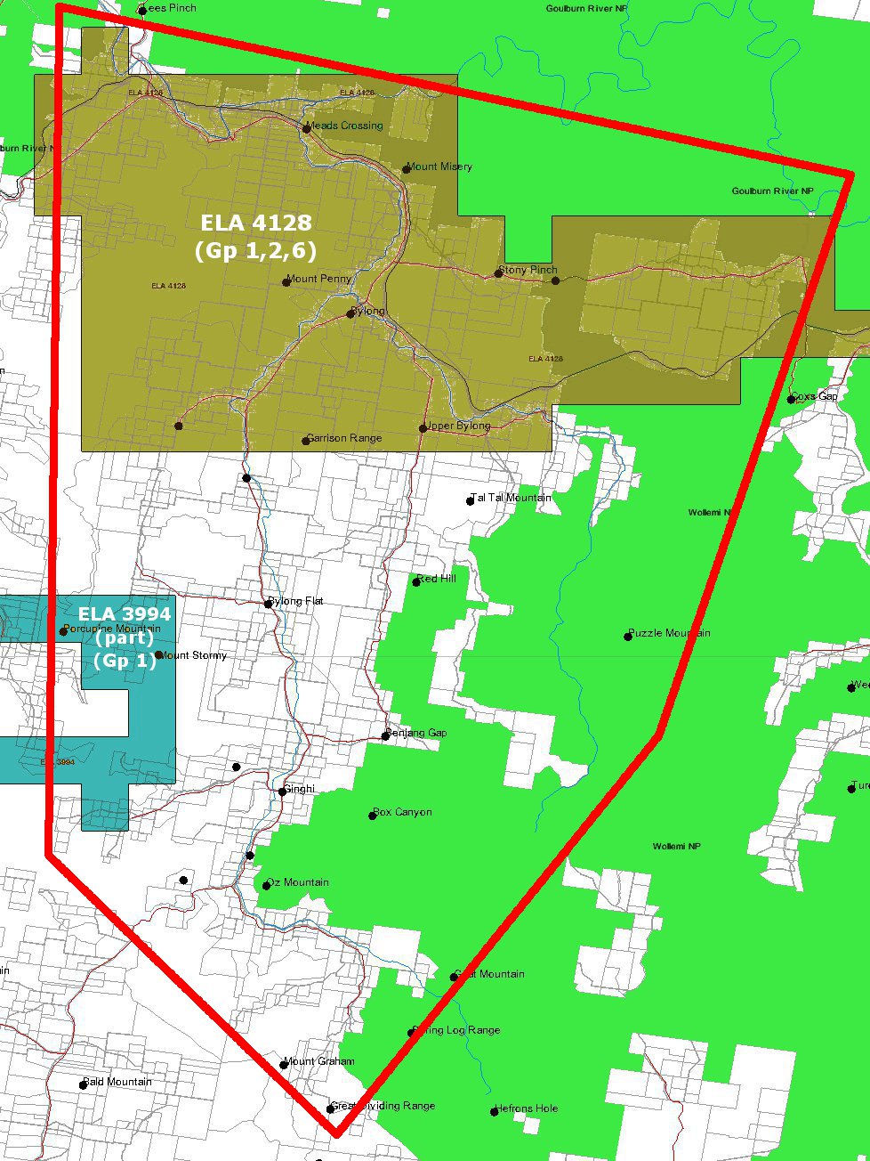
Details regarding each of the ELAs shown in the map are given below:
|
Title Code |
No. |
Act Year |
Company |
Grant Date* |
Expiry Date |
Renewal Date |
Type/Group |
|
MINERAL TITLE APPLICATIONS |
|||||||
|
ELA |
3994 |
1992 |
STRATEGIC MATERIALS PTY LTD |
21 May 2010* |
N/A |
N/A |
Group 1: Metallic minerals |
|
ELA |
4128 |
1992 |
LACCOLITH PTY LTD |
19 Nov 2010* |
N/A |
N/A |
Group 1: Metallic minerals Group 2: Non-metallic minerals Group 6: Corundum, diamond, ruby |
* In the case of applications for title, the date is the application date (not the grant date)
1.2.3. Current Minerals Titles
Current minerals titles are shown in the map below, each coloured differently. (Click for larger image.)
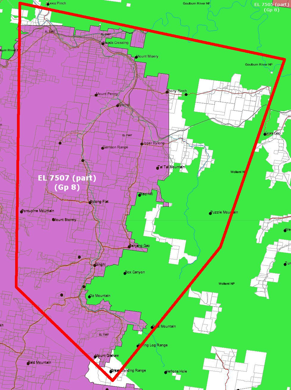
Details regarding each of the ELs in the map are given below:
|
Title Code |
No. |
Act Year |
Company |
Grant Date* |
Expiry Date |
Renewal Date |
Type/Group |
|
CURRENT MINERAL TITLES |
|||||||
|
EL |
7507 |
1992 |
CENTENNIAL FASSIFERN PTY LTD |
07 Apr 2010 |
07 Apr 2013 |
07 Apr 2010 |
Group 8: Geothermal substances** |
|
EL |
7505 |
1992 |
MACQUARIE ENERGY PTY LTD |
07 Apr 2010 |
07 Apr 2013 |
07 Apr 2010 |
Group 8: Geothermal substances** |
** i.e. "hot rock" (for geothermal applications)
NOTE: EL 7705, while shown on the map, is not contained within the Greater Bylong Valley Area as we have defined it.
1.2.4. Current Petroleum (/Gas) Titles
Current petroleum titles are shown in the map below, each coloured differently. (Click for larger image.)
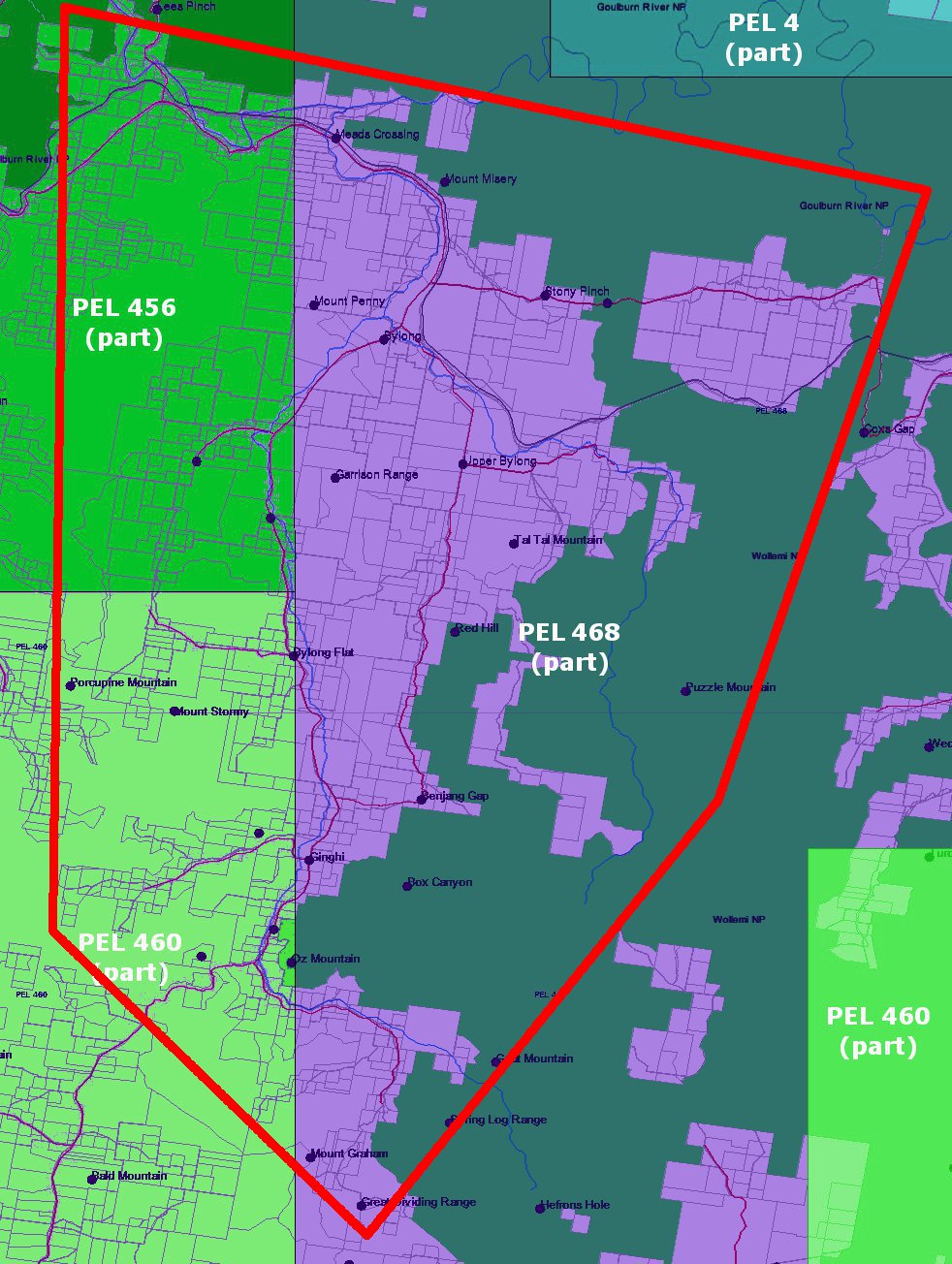
Details regarding each of the ELs in the map are given below:
|
Title Code |
No. |
Act Year |
Company |
Grant Date* |
Expiry Date |
Renewal Date |
Type/Group |
|
CURRENT PETROLEUM (/GAS) TITLES |
|||||||
|
PEL |
468 |
1991 |
LEICHHARDT RESOURCES PTY LTD |
30 Apr 2009 |
30 Apr 2012 |
30 Apr 2009 |
Gas |
|
PEL |
456 |
1991 |
MACQUARIE ENERGY PTY LTD |
05 Mar 2008 |
05 Mar 2012 |
05 Mar 2008 |
Gas |
|
PEL |
460 |
1991 |
MACQUARIE ENERGY PTY LTD |
08 Jul 2008 |
08 Jul 2011 |
08 Jul 2008 |
Gas |
|
PEL |
4 |
1991 |
AGL UPSTREAM INVESTMENTS PTY LTD |
06 Oct 2004 |
05 Oct 2025 |
06 Oct 2004 |
Gas |
NOTE: PEL 4, while shown on the map, is not contained within the Greater Bylong Valley Area as we have defined it.
2. PROJECTS/EXPLORATION
2.1. Mt Penny Coal - EL7406 (Cascade Coal/White Energy)
2.1.1. Current Status (as at 01/03/11)
White Energy (ASX:WEC) has taken up an option to purchase the Mt Penny project from Cascade Coal. The purchase has passed all necessary internal reviews and has board approval. The only remaining step is for shareholders to vote to approve the deal. This vote is planned for April, 2011.
Cascade Coal has applied for project approval under Part 3A of the Planning Act and recently had interim Director General's Requirements (DGR's) issued to it by the Department of Planning (see further below). Cascade have launched a website dedicated to the project: www.mtpennycoal.com.au, while the various documents lodged with, and issued by, the Department of Planning can be viewed here.
Note that the application that has been submitted only deals with Stage 1 of the proposed project, a large open-cut pit and associated infrastructre, with production from this pit scheduled to commence late in 2013 and reaching 5.2Mtpa. It has since emerged that a further three open cut and one underground pit are planned, adding a further 4.0Mtpa in production by 2018.
2.1.2. Project Overview
2.1.2.1. Stage 1
2.1.2.1.1. Overview Presentation
A fairly detailed presentation regarding what we are calling the Stage 1 development is available by clicking here or on the image below. (Note: This is a 6MB download in .pdf format.)
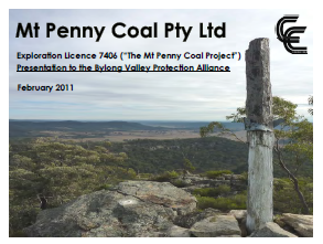
(Click image to open presentation document)
Some of the major proposed features of Stage 1 include:
- An open cut mine producing up to 5 million tonnes per annum of run of mine coai over 21 years.
- The mine will operate up to 24 hours per day, 7 days per week.
- Construction of out of pit overburden emplacement(s).
- Run of mine coal facilities to provide initial coal processing.
- Coal processing plant.
- A staged, bi-directional rail loop with associated train loading and provisioning facilities providing tor transport east or west from the project.
- Coal stockpiles, converyors and associated coal reject handling facilities.
- Construction of a 66kV power line from the Bylong substation to the site.
A layout of the proposed Stage 1 pit (with progress by Year 3) is shown below. (Click for larger image.)

Stage 1 Layout, showing progress by Yr 3 (click for larger image)
A closer view of the proposed infrastructure layout for the project is shown below. (Click for larger image.)
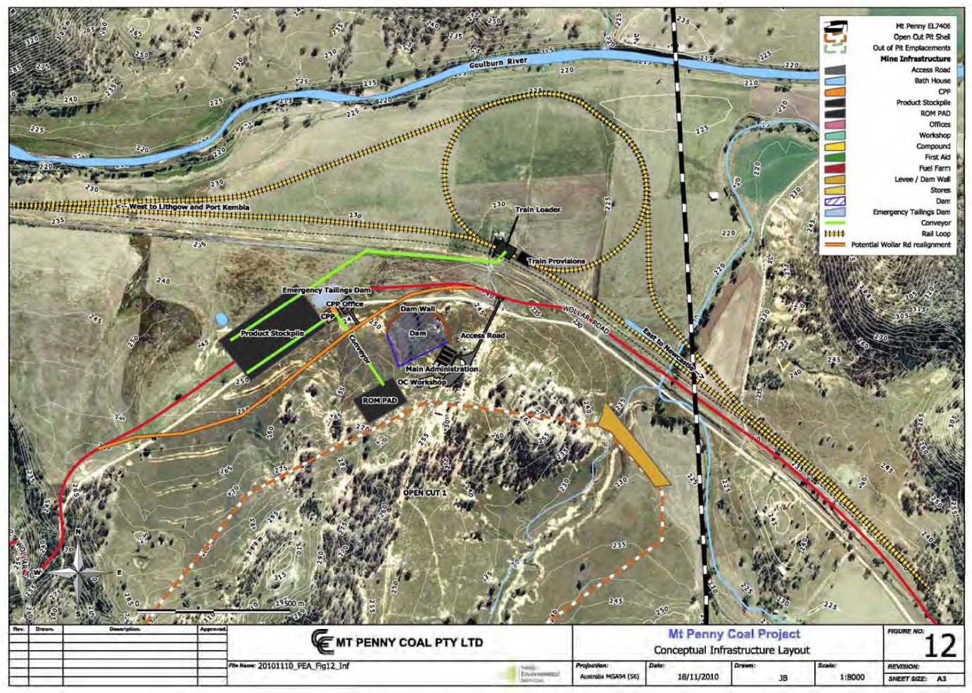
Stage 1 Layout, showing progress by Yr 3 (click for larger image)
2.1.2.1.2. Preliminary Environmental Assessment (PEA)
The Preliminary Environmental Assessment (PEA) for the Stage 1 project is available at from the Department of Planning website (click here - NB: This is a 16MB download). This is essentially a more detailed version of the presentation document referred to immediately above.
Mt Penny Project - Preliminary Environmental Assessment
(Click image to open document - NB: 16MB download)
2.1.2.1.3. Interim Director General's Requirements
Interim Director General's Requirements (DGRs) for the project have been issued and are also available from the DoP website (click here). These requirements document key issues that need to be covered off by Cascade in its full Environmental Assessment when it is eventually lodged. Note that these DGRs are interim, pending the outcome of final consultations with the Mid-Western Regional Council and local community groups.
2.1.2.2. Stages 2+
On 23rd February, White Energy released to the ASX a copy of its 'roadshow' presentation which it is using to sell the benefits of its Cascade Coal aquisition prior to a shareholder vote in March.
The presentation outlines well-progressed plans for the expansion of the Mt Penny project through the addition of 3 further open cut and one underground pit. Total production is planned to rise from 5.2Mtpa outlined in the Stage 1 plans given above, to 9.2Mtpa by 2018.
It should be noted that the planned further open cut expansions - all being outside the so-called 'Coggan Valley' - completely negate the 'visually and acoustically sheltered' advantage that is being pushed as the one of the key advantages in the Stage 1 design.
The diagram below, taken from the roadshow presentation, shows all the pits planned as part of the larger project. In particular, note Pit 3 (the southernmost pit shown) which is on the main Bylong Valley side of the saddle adjoining Mt Penny. (This is largely the 'Cherrydale' property, owned by the Obeid family.)
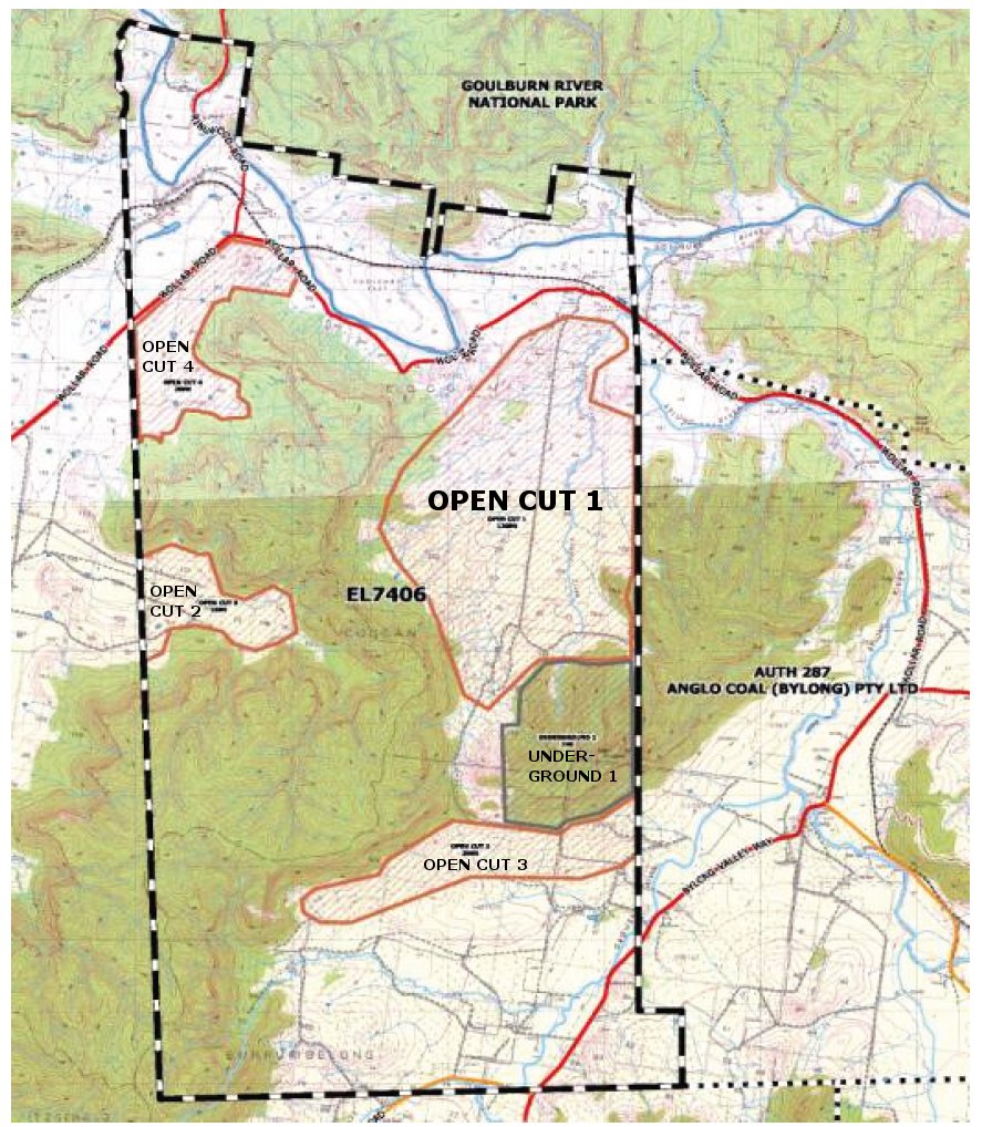
Total planned layout showing 3 additional open-cut pits plus an underground pit (click for larger image)
The tactic of lodging an application for one smaller project then rapidly expanding to a larger project is the same as used in the development of Moolarben mine. Note that key directors involved in the Mt Penny proposal are the same as those involved in the Moolarben development.
The full roadshow presentation is available at this link. (Refer particularly to pages 27-30.) (Note: this is a 3.1MB download in .pdf format.)

(Click image to open roadshow presentation)
2.2. Bylong Coal - AUTH 287 & AUTH 342 (Cockatoo Coal/KEPCO)
2.2.1. Current Status (as at 01/03/11)
Anglo Ammerican Metallurgical Coal has sold its interest in Authorities 287 and 342 to KEPCO of Korea in a transaction worth over $400M. The transaction was finalised in December last year, although our understanding (which may not be correct) is that Anglo is required to complete its exploration requirements. Australian company, Cockatoo Coal, is developing the project for KEPCO in return for a 30% stake in the venture.
Exploration work is currently in progress, with the drilling of a final 18 holes across about half a dozen properties substantially complete. Seismic surveying work was completed about a month ago.
The current Authorities expire around the middle of this year, by which time an application for a mine development will need to have been lodged.
2.2.2. Project Overview
At this stage, no indications relating to actual mine plans are available. There is a deal of speculation locally about where pits and infrastructure might be placed, but none of this information is sufficiently reliable to be published here (for the moment at least).
A deal of information is available, however, regarding the exploration currently underway and the context in which it is occurring. Key relevant details are given in the various sections below.
2.2.2.1. Factsheet
Anglo American Metallurgical Coal (AAMC) produced a two page factsheet (August, 2010) that gives some information about the company and its plans to drill a total of 18 open drill holes as part of its ongoing program. Click the image of the factsheet below to open it for viewing.
.jpg)
Note that, since the production of this factsheet, Authorities 287 and 342 have been on-sold to KEPCO of Korea, with an agreement that further work is carried out by Cockatoo Coal.
2.2.2.2. Land Ownership and Proposed Boreholes
This map shows all the property affected by Authorities 287 and 342 and who owns it. The locations of the 18 original proposed boreholes are marked with blue and crimson circles (depending on the type of borehole being drilled). (Click the map to open a larger image.)
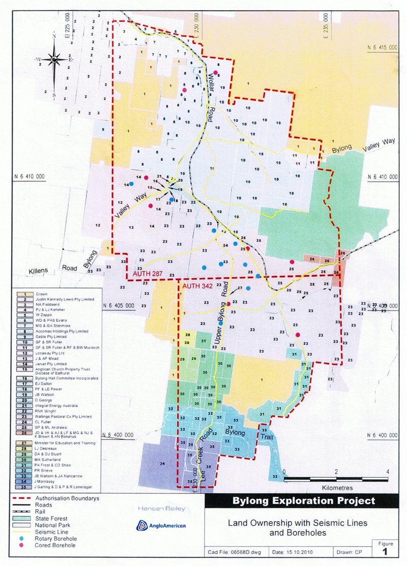
Note that since this map was produced the number and location of holes has changed slightly, but other details remain unaltered.
2.2.2.3. Coal Resources
This geological map gives details of what is currently known about the coal resource in the area, concentrating on the two Authorities now held by Kepco/Cockatoo Coal. The map shows the location of EXISTING drill holes, along with details of the coal found in each case, in terms of seam thickness and % ash content. (Click the map to see a larger image.)
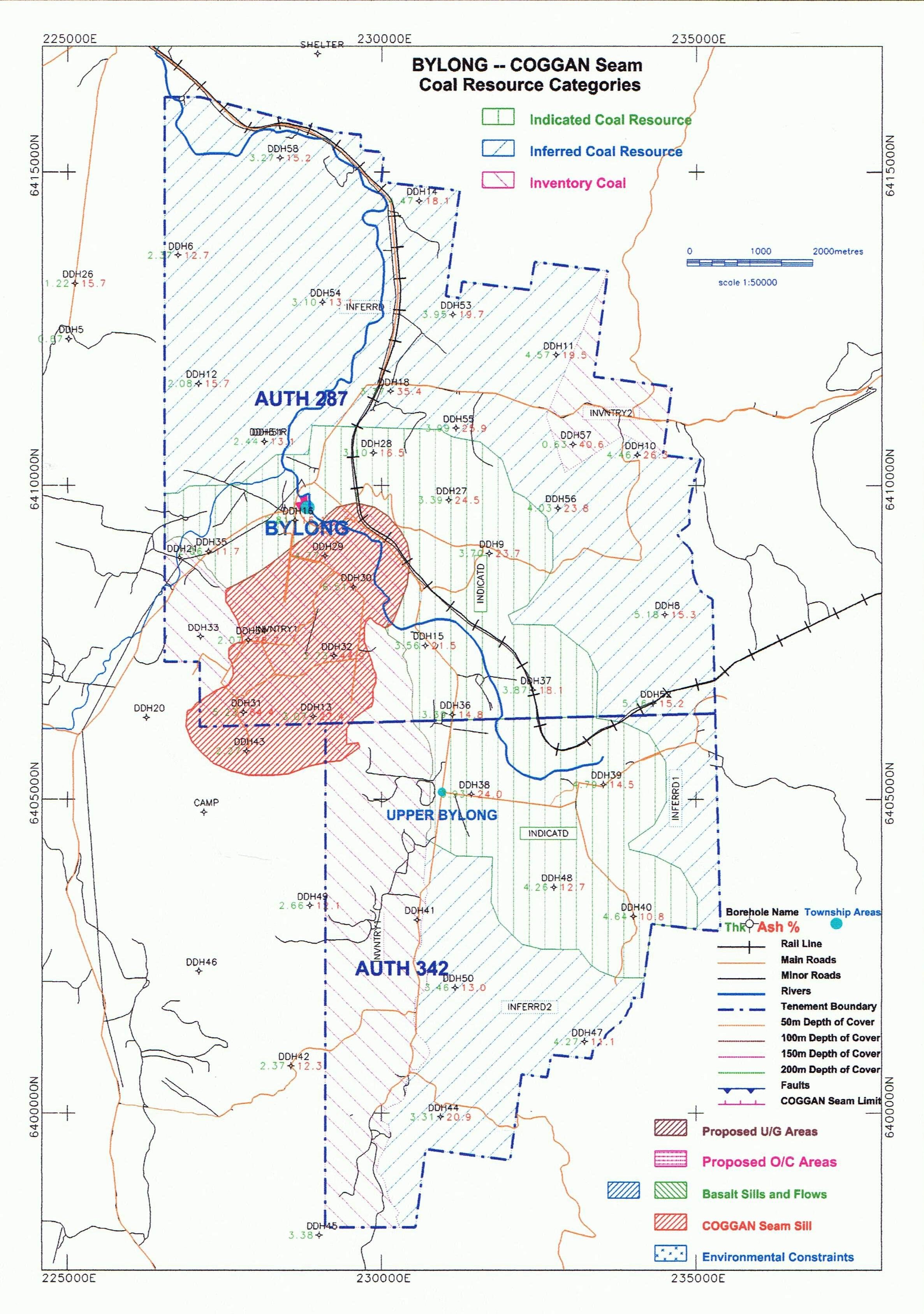
[For reference, the term 'indicated coal resource' means there is enough information to be fairly certain that the coal seam is continuous in this area, but this is not actually 'proven'. An 'inferred coal resource' is where there is some evidence to suggest that a seam in the area may be continuous, but there is insufficient information as yet to class it in the 'indicated' category.]
2.3. Bylong/Murrumbo Gas - PEL 468 (Leichhardt Resources/Planet Gas)
2.3.1. Current Status (as at 01/03/11)
Leichhardt Resources is the owner of PEL468. Exploration work is being carried out for Leichhardt by Planet Gas, in return for an equity stake in the PEL. Coordination of "on-the-ground" work by drillers, seismic surveyors, ecologists and aboriginal heritage experts is being coordinated by Queensland-based company MBA Petroleum Consultants.
Ecological and aboriginal heritage work is currently being undertaken. The Review of Environmental Factors (REFs) for planned drilling and seismic work have been lodged and it is expected that this work will commence late March / early April. The work will comprise two separate drill holes and around 30km of seismic work along sections of the Bylong Valley Way and Wollar Road.
2.3.2. Project Overview
Note that this project is currently still at the exploration stage. Various pieces of available information are outlined in the sections below.
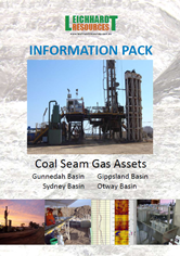
2.3.2.1. Summary Information From Leichhardt Resources
The Leichhardt Resources website has a link to an information pack containing info on its various projects, including PEL 468 (see pagegs 3 and 5).
(Click image to open .pdf document)
2.3.2.2. Exploration Project Details (as at 24/01/11)
The following information regarding the project - provided by MBA Petroleum Consultants - has been made available by Mid-Western Regional Council.
MBA Petroleum Consultants has been engaged by Planet Gas Ltd to plan and manage an exploration programme comprising 30 kilometre 2-D seismic and two exploration coreholes in PEL 468, approximately 50 km east of Mudgee. The two coreholes will be drilled to depths of 750 metres to evaluate the geology of the area.
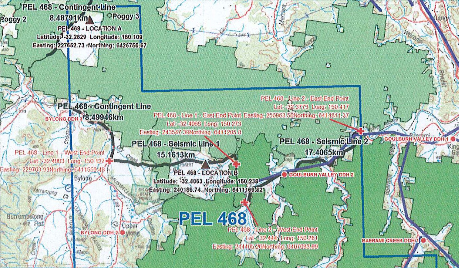
Location of planned seismic lines (click for larger image)
PEL 468 has limited seismic data on which to locate a well independently of the proposed 2011 Bylong Seismic Survey. The seismic survey will be conducted along public roads including sections of the Bylong Valley Way and Wollar Road, and a cleared freehold section in the Goulburn River National Park passing Poggy Station.
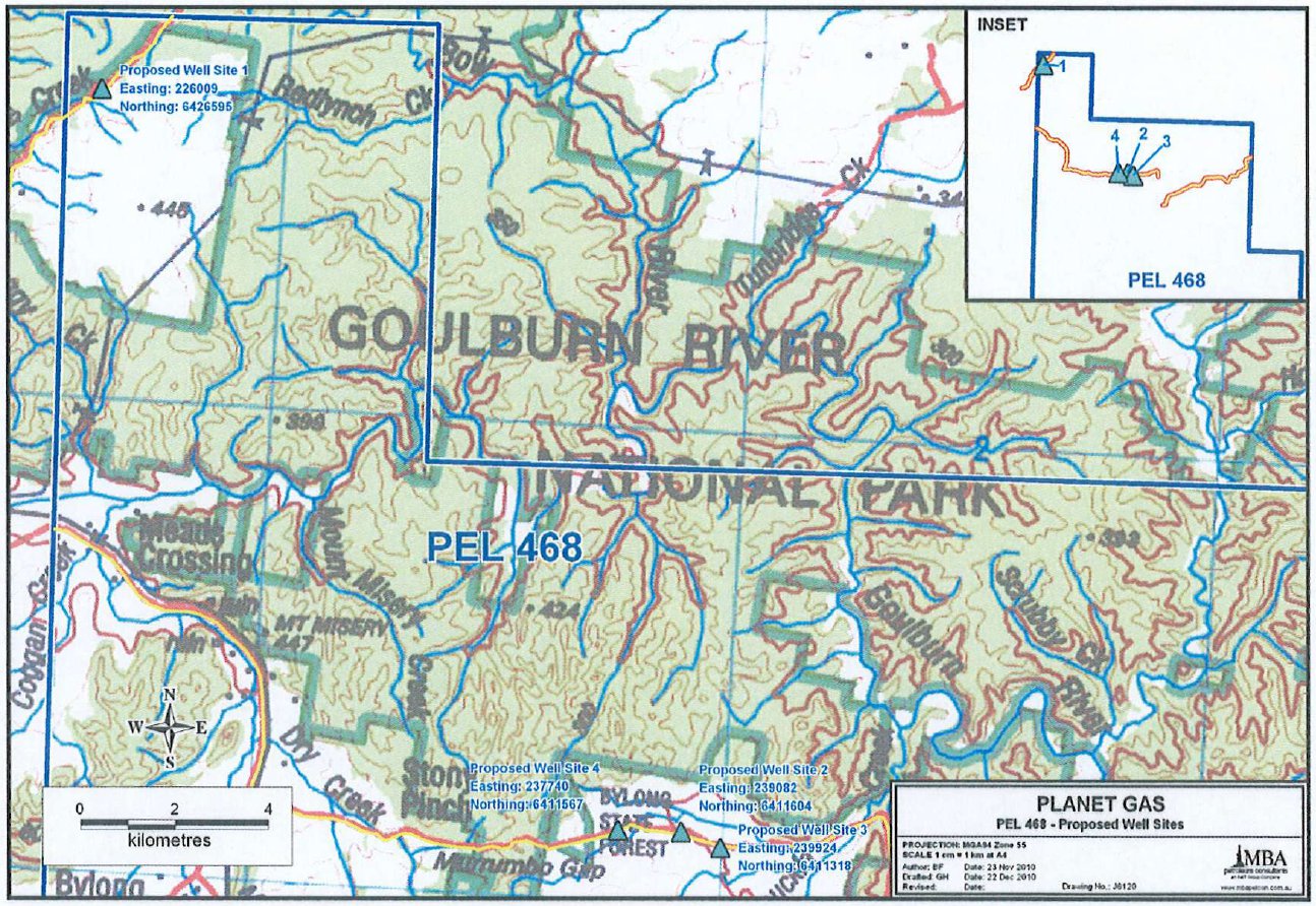
Location of proposed coreholes (click for larger image)
MBA has, on behalf of Leichhardt, prepared and submitted the pre-requisite REF for the seismic programme and a drilling REF for two proposed coreholes is in preparation. The coreholes will be cored and logged for data and will be plugged and abandoned upon completion: low invasion drilling fluid will prevent possible contamination of aquifers, no well testing will take place and no fluids will be produced to surface prior to filling the coreholes with cement.
The proposed survey and corehole programme will occur in late summer to autumn but hot conditions may be anticipated; appropriate controls will be in place to prevent initiation and propagation of fires as this threat is rated a significant risk to the environment and peripheral stakeholders. MBA will co-ordinate a process of public consultation via the local media as well as advising road users about traffic management for the proposed seismic programme. Applications for Road Opening permits will be lodged as the timing of the seismic programme approaches.
2.4. Bylong/Murrumbo Minerals - ELA 4128 (Laccolith/Murrumbo)
2.4.1. Current Status (as at 01/03/11)
Little is known about this application and its current status.
Laccolith Ltd (ACN 147 439 030) is the applicant for ELA 4128. The company has its registered office in New Farm in inner Brisbane. Directors include Andrew Tunny and Christopher Vose (who is also Company Secretary).
Laccolith's ultimate holding company is Murrumbo Ltd (ACN 147 437 250), formed on the same day as Laccolith and with its registered office at the same address. Its directors are the same as for Laccolith, with the addition of Natasha Stevenson as a third director and Company Secretary.
ELA 4128 covers minerals in Groups 1 (metallic minerals), Group 2 (non-metallic minerals) and Group 6 (corundum, diamond, ruby and sapphire).
(For reference, a laccolith is a dome or mushroom shaped geological formation resulting from the intrusion of magma between two layers of sedimentary rock. This kind of structure is present underground at Murrumbo.)
2.5. Bylong/Barigan Minerals - EL 7696 (formerly ELA 3994) (Strategic Elements/Strategic Minerals)
2.5.1. Current Status (as at 01/03/11)
Originally ELA 3994, the application was granted on 2/2/11 and the area involved is now known as EL 7696. (Note: Various maps on this site still show ELA 3994. We expect to update them in the next couple of weeks.) The licence is for minerals in Group 1 (metallic minerals); the focus is rare earths. While some information is available concerning the geology of the area covered (see below), no information is currently available in relation to any planned program of exploration.
2.5.2. Companies Involved
Strategic Minerals Pty Ltd is 100% owned by Strategic Elements Ltd (www.strategicelements.com.au), headquartered in Perth. Strategic Minerals is developing a number of rare earths and rare metals exploration projects. Apart from EL 7696 (which it refers to as the Rylstone Project), the company has a number of projects/exploration areas in the South Island of New Zealand, as well as exploration area in Queensland (Mt Ramsay).
2.5.3. The Rylstone Project
A good deal of geological information is available on the Rylstone Project, compiled by Southern Geoscience Consultants. The project area contains a number of intrusions that are considered prospective for rare earths mineralisation. The Bald Mountain phonolite has the largest exposure of these, measuring 1.9km x 1.6km and is a distinct outcrop in the southern part of the project area.
A .pdf of this information - taken from a recent Strategic Elements prospectus - is available at this link (or by clicking the image below). Also note that the Strategic Elements website contains a lot of useful background information relating to rare earths and their uses etc.
(Click image to open .pdf document)
2.6. Bylong/Barrigan/Wollar Geothermal - EL 7507 (Centennial Fassifern)
2.5.1. Current Status (as at 01/03/11)
EL 7507 is for 'geothermal substances' (i.e. 'hot rock') and is owned by Centennial Coal via its subsidiary, Centennial Fassifern Pty Ltd.
In its latest annual report, Centennial talks only in the most general terms about its geothermal projects, giving no specifics in relation to EL 7507:
Centennial has been granted three geothermal exploration licences: Two of these licences cover an area to the north and east of Centennial's existing western mines at Airly and Charbon. The third is adjacent to Centennial's Awaba and Mandalong mines in Lake Macquarie.
Deeper granites occur in these areas and are a known source of heat energy that could potentially be used for power generation.
Centennial has well established mining operations and infrastructure in these areas to support any future exploration and feasibility activities required to understand the type and location of any geothermal resources.
Assessment of these areas has commenced and a specific exploration strategy for each area is being developed.
[HOME]